

A herd of sheep, in need of sheering, stiffened and crowded together as we approached from over the pass. Their shepherd sat on a rock and smoked a cigarette. From time to time he popped a switch against the rock and called out to the shaggy congregation. They looked up, stared blankly and then pointed their snouts back into the green grass.
When we told the shepherd where we were headed—to the tri-border point where Albania, Montenegro, and Kosovo meet—he paused and lit another cigarette. It was summer but he wore a wool sweater and dark trousers. He told us that the next pass was two hours away. He pointed his switch across the expanse toward a 7,000-foot mountain wall, where pockets of snow still sat in crags—the backdrop for this natural amphitheater.
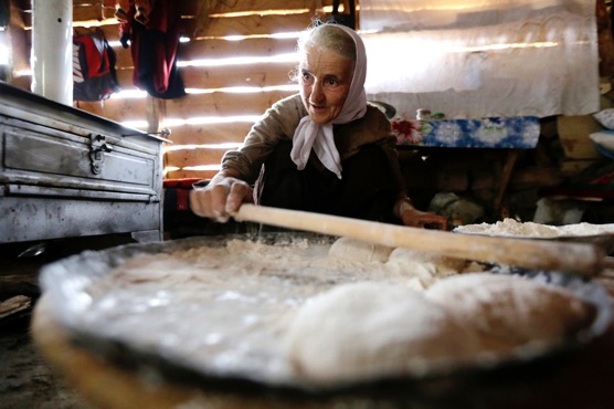
Stone houses, cobbled and re-cobbled over centuries, stood watch over sections of the meadow. Each had a 10-foot-high haystack. Wooden pitchforks leaned against the carefully shaped mounds. The plots of land were delineated with ancient wooden fences: tree branches twisted and woven together. As we passed, residents stood and waved—happy for the brief company. Some offered coffee. We drank raki, an Albanian liqueur, with one family. After two shot glasses of the elixir, the father told us that he believed the pass was three hours away.
On the surface, there was nothing inherently odd about walking across that field in northeast Albania, an area known as the Albanian Alps. For hikers in Europe—especially in the more familiar Western Alps—the scene, though more rustic, is a familiar one. What was odd is that just 25 years ago not only would foreign trekkers be unheard of, their existence here, which was still under the grip of a 45-year dictatorial regime, would have been tantamount to espionage.
![]()
The power of tourism and travel to reinvent previously unexplored regions of the world was not lost on our group as we walked across the Balkan Peninsula in Southeastern Europe last summer on a brand new “mega” hiking trail called the Via Dinarica. The trail follows the highest peaks along the Dinaric Alps range and incorporates the regional massifs that are immediately tangent. In fact, the very purpose of our trek was to encourage that reinvention. The route connects the countries of the Balkans’ western half—portions of which were embroiled in war less than 20 years earlier—in a way not thought possible: peacefully, naturally, and with a sense of cross-cultural cooperation. The path includes, from north to south, Slovenia, Croatia, Bosnia and Herzegovina, Serbia, Montenegro, Albania, Kosovo, and Macedonia.
The purpose of the trail is to act as a vehicle for adventure tourism and as a corridor linking some of Europe’s last remaining Old World culture. This corridor has the potential to serve as a business engine, in a part of the world that has natural resources in spades.
But the all-important word here is cooperation. This region has seen its share of well-documented conflict and hardship. But, the hoped-for result of this trail is to highlight one of the most beautiful, unheralded, and unspoiled stretches of land on the continent. By coming together with a sense of camaraderie, countries have put aside decades of strife and differences and now work in harmony to host travelers and show off similarities, namely unspoiled, rugged landscapes and ancient culture.
Driving this point of reinvention home one step further, the trail runs through the heart of the National Geographic Western Balkans Geotourism Mapguide Network of countries. The collaboration codifies a style of tourism that places the destination and the preservation of its authenticity as the highest ideals. The Western Balkans Network includes Albania, Bosnia and Herzegovina, Kosovo, Macedonia, Montenegro, and Serbia.
What does all this mean for travelers? What does this reinvention do for a couple from Middleburg, USA, for instance? Perhaps nothing … besides having a trusted name—National Geographic—backing the region and a couple of sophisticated resources to research an area that has been on Mr. and Mrs. Middleburg’s bucket list radar for years. However, as a group we travelers have grown to expect such convenience.
But, the power of reinvention cannot be overestimated in this area of Southeastern Europe, where the misrepresentation of the word “Balkans” has worked against millions of people for generations. Reinvention means this corner of the world has committed to working together to build a tourism brand and has admitted that doing so could mean the difference between success and failure.
![]()
For each country to individually overcome centuries of occupying empires, decades of dictatorships and years of economic crisis—plus a dramatic shift from managed socialist economies to free enterprise systems—would seemingly be enough to make one stand and applaud. But the individual agendas for success is expected and somewhat obvious. Every country looks to push its own interests. Nations are inherently and proprietarily preoccupied with promoting their own tourism industry. The reinvention here, however, is of historic proportions because the region is doing it together. In the tourism world, successful cross-border cooperation is rare indeed. The Balkans, however, upped the ante at the tourism-reinvention poker table by throwing in another chip: post-conflict cooperation.
Even attempting this bold move would be like getting a royal flush for two hands in a row in Vegas. Seen another way, for all you birders out there (you know who you are), a cross-border, post-conflict combo is like seeing a yellow-billed cuckoo and a red-necked phalarope on the same day. When one throws in the fact that the region still has stunning, largely untouched landscapes, clean rivers, lakes, mountains, and the Adriatic Sea, the confluence of cross-border, post-conflict, and undiscovered travel is, in the tourism world and for explorers everywhere, something like spotting Sasquatch riding a unicorn.
So what does all this reinvention ultimately mean?
It means that most travelers will never be aware of the regional sacrifices necessary to make a holiday here possible. It means we can all now lace up our boots and hoist our packs along the untouched beauty of the Balkans’ Via Dinarica trail. It means we can relax, tip our flasks, and roll our cigarettes after a day of hiking and as a moon rises over the peaks in Southeastern Europe. It means we can take photos from our mountain huts with alpine views to one side and crystal-clear Adriatic vistas to the other. It means we can visit countries our parents could not. But it also means we should know that it took thousands of years for this region—and many others across the planet for that matter—to get to this point in tourism history.
There are no overnight successes. Reinvention takes lifetimes.
Elma Okic is a Bosnian-born, Switzerland-based photographer and videographer, who regularly covers travel, music and the environment.
Sarajevo-based Alex Crevar is Paste’s travel editor.